
Beautiful panoramic views abound on Jebel Akhdar
If you’re looking for something to do near Muscat during the summer months, the mountains are your answer! The temperatures are literally 20 to 30 degrees (Fahrenheit) cooler and there are lots of neat places to explore.
We’ve done a number of different hikes on Jebel Akhdar. None of them are flat, but some are easier than others. Here are five hikes that we’ve done on Jebel Akhdar, listed in order from easier to hardest.
- Wadi Bani Habib: This is a good, easy hike for exploring abandoned villages There is a public bathroom (it’s in rough shape) and go down the stone stairs. There’s an abandoned village immediately in front of you as you go down the stairs, but if you turn left and walk through the wadi a little ways, you’ll find a better one to explore. Turn right when you’re across from the well-maintained pomegranate farm, by a stone structure. The trail is a little tricky to see, but it climbs up the mountain with some rough stairs, and you’ll reach the village. Depending on how much time you spend exploring the abandoned villages, this takes between 90 minutes to two hours.

The first abandoned village you’ll see at Wadi Bani Habib

The second abandoned village, which is more fun to explore

Windows in village #2
- The Village Walk or W18b: This takes you through farmland and villages and has terrific views. If you want the stereotypic Jebel Akhdar views, do this hike. Drive to GPS 23.0722, 57.6666 to start the hike. When you reach a point where you’re hiking through a rocky little gorge and the trail markers seem to end, turn right by the mosque and go up the sidewalk to the road. If you go all the way to Sayq, it takes about 2:30 hours.

Sights along the Village Walk

Village Walk views
- Mirage in the Mountains: This hike starts right across the street from the Alila entrance gate. There’s not a lot of steep climbing or drop-offs, and it ends at an abandoned village. This hike is more undulating than most. You’ll reach a point in the wadi bed where you can turn left or go straight. Turn left and you’ll go up a mountain, from which you’ll follow the ridge line to the village. Go straight and follow the wadi to the village (we didn’t take this route, but I imagine it’s less physically strenuous, although the views wouldn’t be as nice). The entire trail takes about 3:30 hours.
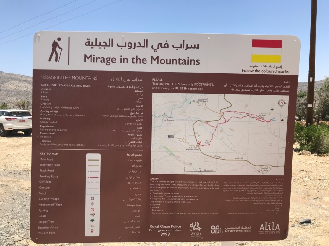
What?! Legible, accurate information about a trail? A definite first

The view on the hike back to the trailhead

Desert roses along the trail

The view towards the trail end, where the Discovery Trail (next on the list) also ends
- Discovery Trail: This one starts up towards the Alila and it is completely downhill, until you turn around and it’s all uphill. I’ve ranked this one as harder than the others because there are some pretty steep drop-offs with nothing below. Take one wrong step and you fall off a cliff. But the hike itself is not too steep. The whole thing takes about three hours.

We found two trail maps in two days!

The hike winds out down along the wadi

Just follow the painted flags and/or the green dots. Why they chose green trail markers in a place known as “The Green Mountain” is beyond me. They might as well have picked tan markers.

The view in the other direction from the last photo in the “Mirage in the Mountains” hike
- W24: This hike starts at GPS coordinates 23.092656, 57.730965, and you basically just follow the white swatches on the rocks. It’s a 3 kilometer hike to another trail that will take you to Wukan or Hadash. This is definitely more a trek than a walk. You need to be very careful where you step so you don’t break an ankle. The first half is unrelenting and up a mountain (which is where we turned around), and from here it follows the side of a mountain to the other trail. If you hiked to the other trail and back, it would take about three hours.

Up, up, up, following the painted white swatches. Oh, you don’t see the white swatches? Welcome to this hike.

The view out over the valley from a mountain halfway through one-way of the hike

The hike was largely made of rough volcanic rock, which would tear your knees and hands to shreds if you tripped

The hike back down the mountain. The starting point is the village in the middle of the photo


There are lots of other hiking trails on Jebel Akhdar! These are just the ones that we’ve done and enjoyed. The best way to explore Jebel Akhdar is hike during the day and then camp or spend the night at a hotel. This way you can get as much enjoyment as possible out of the cooler temperatures, plus you get to see a beautiful sunset and sunrise!

We’re off to Jebel Akhdar tomorrow, really looking forward to it! Have done a couple of these hikes but hadn’t seen the ones from the Alila, will have to check those out. Thanks for sharing 🙂
We didn’t know about the ones by the Alila until we were actually driving to the Alila, but they are surprisingly pleasant and well-marked hikes! I hope you had fun up there, and thanks for reading!